3/11/2022 Ogden Skyline Traverse Trip Report
It’s been a weird winter here in the Wasatch thanks to an unusually prolonged mid-season dry spell. But with high pressure comes stability and with stability comes the chance for creative ski days. Ogden skier Jules Goguely and his partners made the most of this opportunity in January. Featuring cruddy snow and lots of question marks, the team decided to link up a route that traversed the skyline of their backyard. Thanks to Jules for sharing this trip report with us.
----
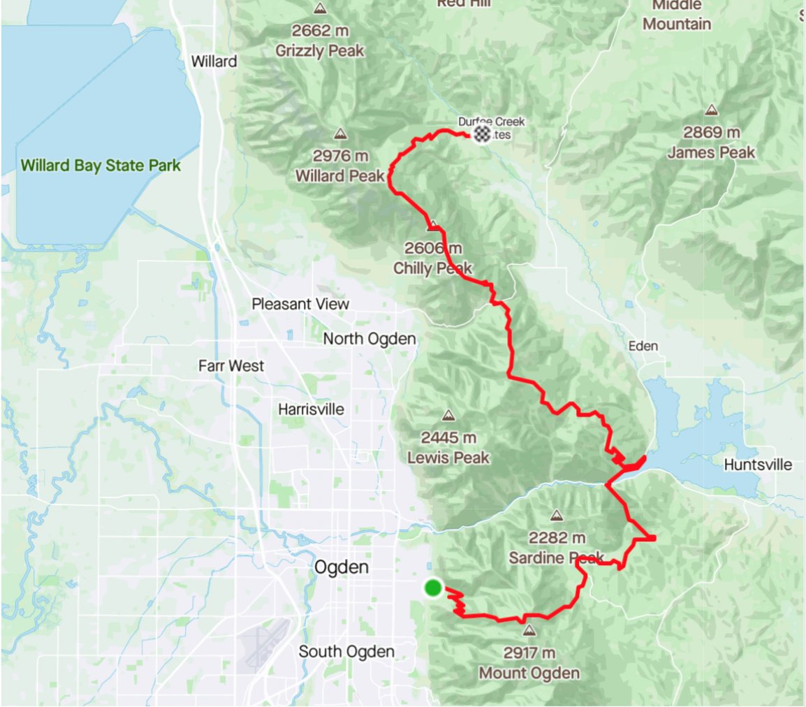
Ogden Skyline Traverse:
34miles / 11’500ft / 11:30hrs
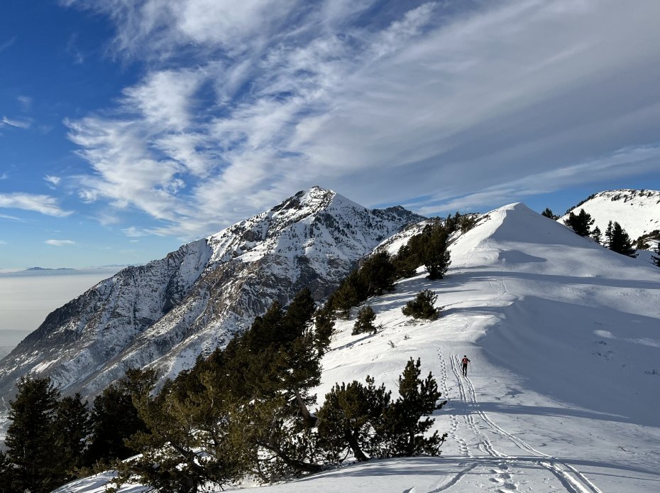
Living in Ogden, and most cities in the Wasatch for that matter, the mountains give off a surreal impression of their size and perception of distance. They seem unrealistically close and distant at the same time.
I started to wonder, a couple weeks before this project, if skiing the skyline that connects South to North Ogden would be possible. I see it every day and dream of ski lines while walking my dog around the neighborhood. Scott and Colby - my touring partners - and I had skied or heard of people skiing parts of it but never significant parts of the route at once. Having a blank slate for a project is both a lot of fun and a bit overwhelming at times as there aren't any references or anyone we can study or ask questions. It allows us to be creative in our route planning, which is part of the fun of skiing in the mountains.
Our first concern was to figure out if we wanted to try and ski it north to south or south to north. Both had pros and cons: skiing north to south would allow us to have quicker climbs and longer descents on skis, and to ski down the iconic Banana Chute. Unfortunately, uphill travel through Snowbasin resort is prohibited during the day. Going south to north had the advantage of dealing with the long sections of melted out southerly aspects uphill with our skins on rather than trying to ski a torn up seven mile section of trail without being able to leave the path. We decided on the latter and would start in Ogden and finish at North Fork Park. This route would add 900 extra feet of vert to an already big day (34 miles, 11,500ft) but it seemed much more manageable logistically.
With a rough route in place, Colby and I scouted the nine mile middle section that we had never checked out on a Saturday. A popular hiking and MTB trail in the summer, it was well packed in with snowshoes which made skinning a bit bumpy but we were happy not to have to break trail! The downhill section was horrendous, punch crusty, bushwacking - but that's what we had expected. With the lack of snow in the forecast and the warm spell we had in January, we figured all the south facing trails would be melting quickly and if we wanted to pull this off it would need to be done soon.
By ‘soon,’ we figured the very next day sounded great. We optimistically texted our friend Scott, told him about our plan, that we estimated it would take us around 12 hours, that there would be a mile and a half section of walking on pavement to cross the dam, and that our only water refill opportunity - unless we arranged an additional water cache - was about 7.5 miles in once we dropped down into Snowbasin. Scott was stoked to join us and it helped to give Colby and I the extra motivational push we needed to tackle this.
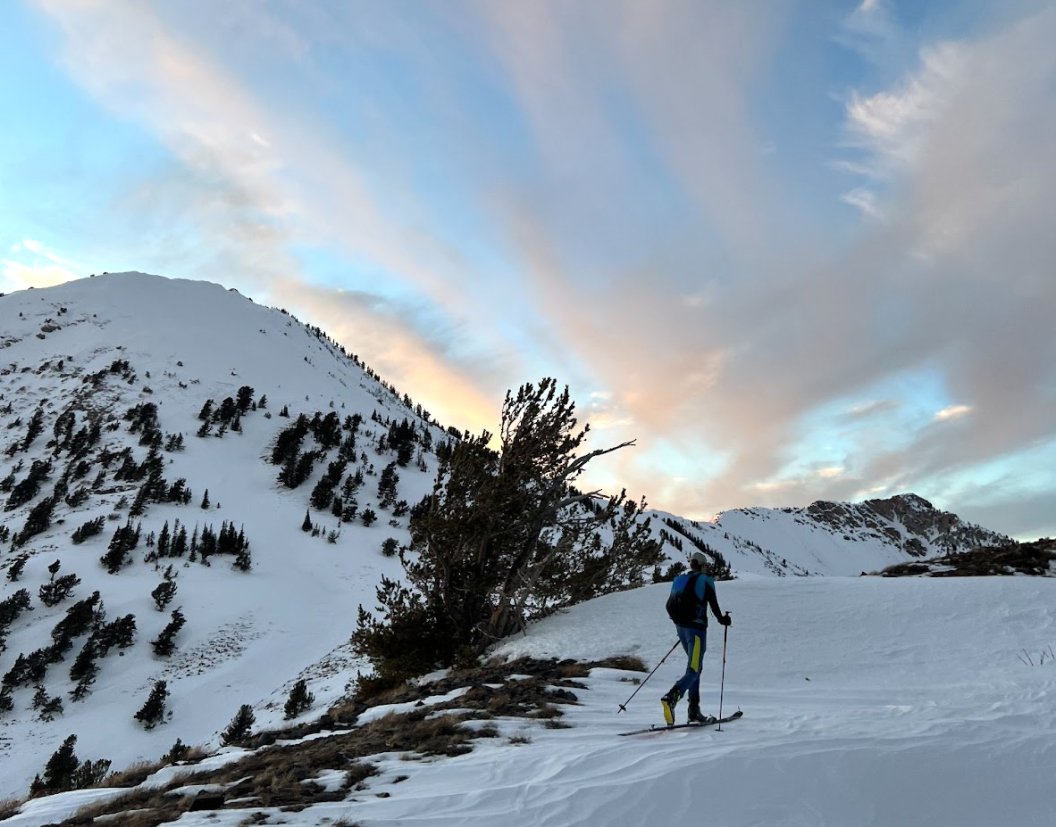
The three of us started at the 27th St trailhead in Ogden, 6:30AM, sneakers on, skis and boots on our backpack, headlamps on, and began hiking up Malans. A popular local climb for hikers year round, the trail was nicely packed in. The first hour in the dark went by relatively quickly and Scott excitedly set a fast pace up the trail until we got to the overlook. There we were able to transition, put boots on, throw sneakers in the pack, and start skinning.
The section from Malans to Allen Peak was a bit of an unknown for us. We figured all we had to do was follow the ridge. It can’t be that complicated... The next two and half hours turned into a combination of breaking trail, bushwacking, bootpacking, scrambling, and carefully side stepping across a very icy steep face.
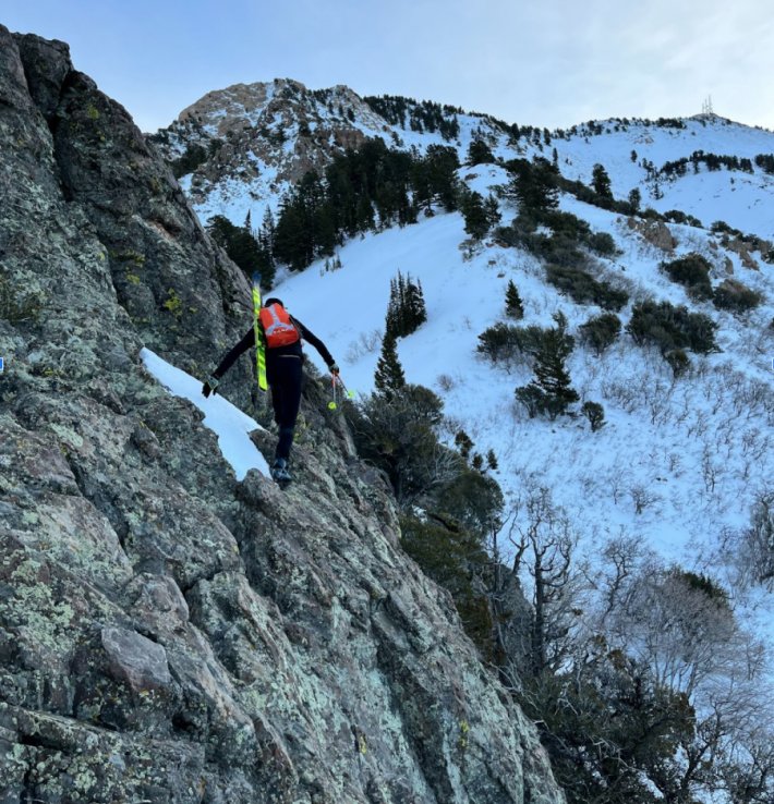
We were moving a bit slower than anticipated and the realization that we were just getting started took the wind slightly out of sails. Nonetheless, navigating the ridge ended up being the most memorable part of the route in my opinion since it was the most technical section and required us to figure out the route as a group, on the spot, instead of blindly following a set path. At the top of Allen Peak, we were treated to some beautiful views, transitioned, and dropped down into Snowbasin resort.
Four hours in, we stopped at the main lodge to fill up our water bottles, re-apply sunscreen, and eat some snacks. Miraculously, our friend David, a resort employee, happened to be on his lunch break, and had just picked up some coffee and a breakfast burrito. After spotting us amidst the crowd of resort skiers, he generously offered us his food. He was stoked to see us and hear about our planned route. Likewise, we were happy to come across a friendly face and that burrito was absolutely delicious.
Spirits back up, we were ready to tackle the next section. We clicked back in to ski down Old Snowbasin Road and Wheeler Canyon before putting on our sneakers for the 1.5mile hike across the dam.
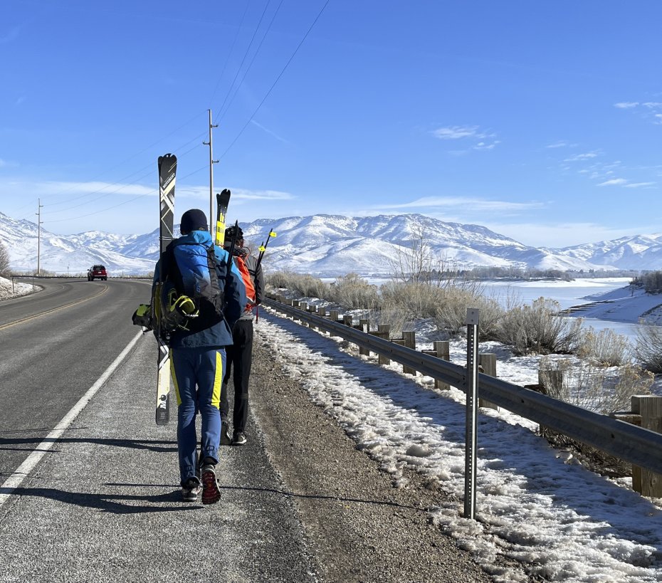
After almost five hours of “skiing,” it sure felt good to have sneakers on for the 25min walk.
I had split up the route in three sections and now we were about to tackle the middle section, the one Colby and I had recon’d the day before, which made it quite a bit easier mentally. We knew what we had immediately ahead of us compared to the first and last section, both of which featured unknown terrain to us at the start.
It was getting really warm at this point. Gloves, jacket, and beanie came off in an attempt to cool off while we felt blisters forming in our sweaty boots. The long day of exertion was also evident as there was less talking and bigger gaps between the three of us as we followed the trail to the summit.
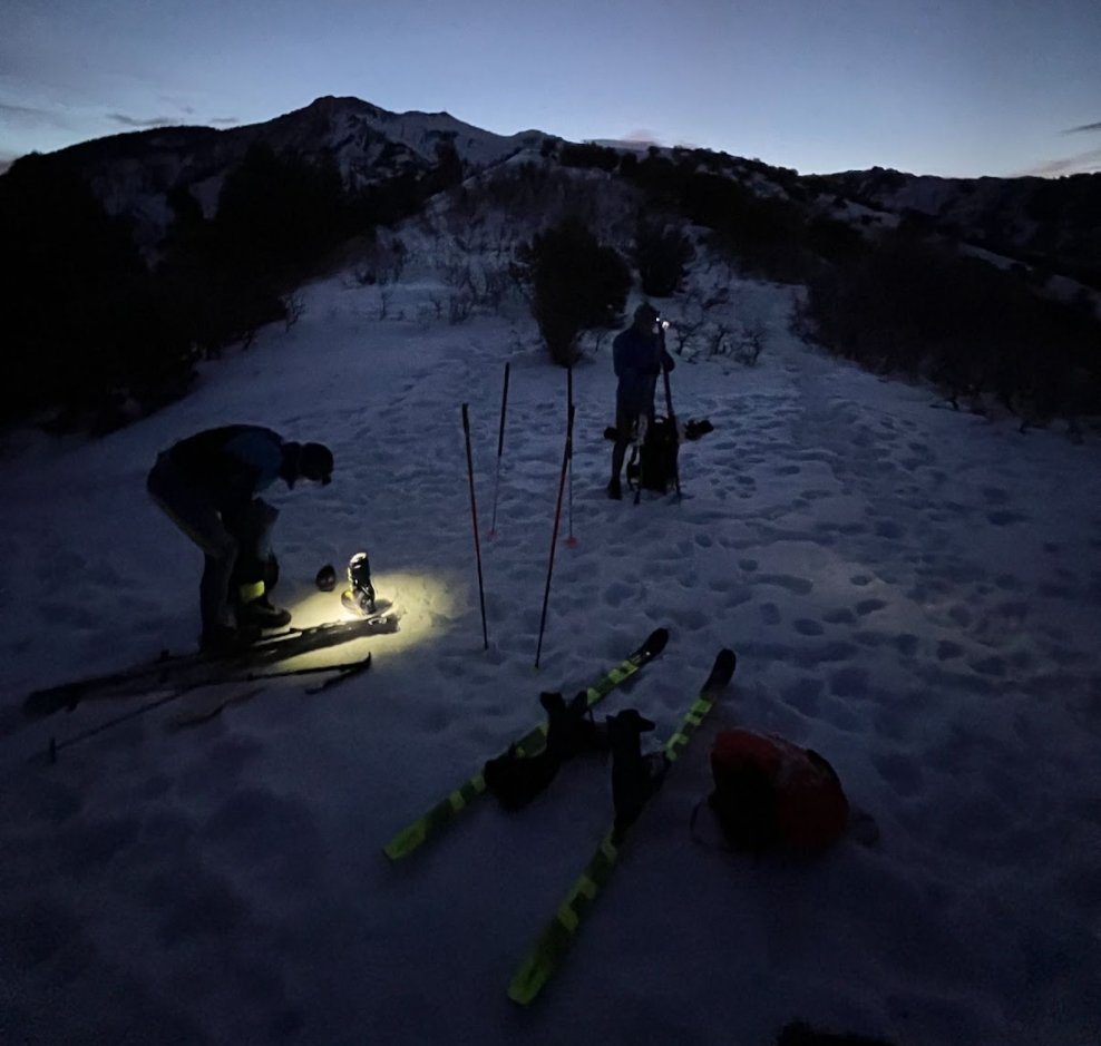
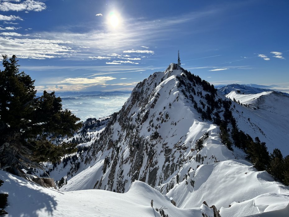
Eight hours in, we reached our second main summit, Eyrie Peak, and started the sketchy-crusty-bushwacking ski down towards the North Ogden Divide. Since Colby and I had skied this section the day before, we were pretty undeterred by the terrible downhill conditions - something we like to call “survival skiing.” However, with 65mm underfoot skis and the right mindset, this type of skiing can be a “fun” challenge. 8.5 hours in, at the North Ogden Divide parking lot, Scott called it a day and was able to hitchhike back to town. He didn’t want to risk crashing and getting injured on the next section, especially as night was approaching.
We were bummed to see him go, but that was the safest option as we knew we had at least another three hours in front us, possibly even some night skiing. And considering the current conditions, it would be another round of survival punch crust bushwacking skiing down to the final trailhead.
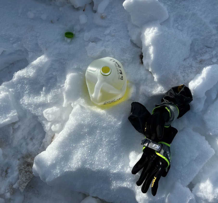
Midway through this second section of the route, I texted a friend, Alan, who was able to fill a milk jug full of water and electrolyte in the parking lot for us to pick up. Lemonade flavored drink mix in a clear jug stashed behind the parking lot toilets may have seemed a bit questionable to the family of hikers who saw us chug most of it down. Thankfully, this brought Colby back to life as he had forgotten most of his snacks at home while quickly packing to meet us.
Colby and I tackled the last climb, a little over 6 miles and 3,200’ left, towards the saddle underneath Ben Lomond Peak. Setting a track on some very wet south facing slopes we were swapping out turns breaking trail. Once we got to the ridge it felt like an eternity to get to the Cutler Ridge Saddle, where we wanted to drop in for our final descent.
Knowing this was the last push, we were able to keep creeping the pace up despite both of us being spent, uncomfortable, and our feet destroyed. Eleven hours in, we took our skins off for the last time once we got to the Ben Lomond Saddle and started our final descent.
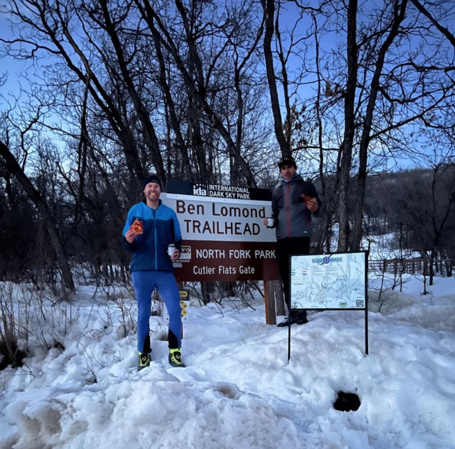
Depending on your current state of mind, getting to the closing stage of a big day in the mountains can be either a huge relief since the end is near, or, a wish that you could keep going. For us, a sense of realization started to creep in, the acceptance that this full day of adventure was coming to a close and we must return to reality. The sun was just setting, we turned on our headlamps and tried to ski as fast and safely as possible to avoid getting caught in the dark and cold. We had both skied this section countless times previously as Cutler Ridge is one of the most heavily trafficked backcountry routes in Ogden. Despite knowing the route well, and what is normally a pretty easy downhill run, we were both stopping every five minutes to recoup. Our legs were blown, feet blistered everywhere, and we had to ski in the backseat through the rest of the breakable crust to avoid falling head over heels. The run eventually popped us out at the Nordic Center at North Fork. We were relieved to cruise down to the parking lot on a nice groomer to meet my girlfriend who had just arrived at the parking lot to pick us up, with some fresh pizza and beer.
After starting around 6:30 AM in the dark, we finished just before 6PM.
It was a long day of type 2 fun, but very rewarding to be able to find adventure and challenge in our backyard. Skimo and backcountry gear is a great way to travel our local landscape in ways we otherwise couldn’t. It was exciting to be able to achieve this route even though it didn’t have any steep couloirs, knee deep fresh powder, or any other stereotypically ‘good’ ski features. Too often, we associate big mountaineering objectives with a high level of risk involved. Part of what made this route appealing was the lack of high risk terrain, which enabled us to push our endurance capabilities further than we would have. The whole route being visible from town, makes it easy to share our story with locals and I often catch myself daydreaming about the experience while running errands around Ogden and catching a glimpse of the skyline.
------
Jules Goguely is a 28-year-old graphic designer and endurance athlete based out of Ogden, UT. Goguely primarily competes as a professional mountain bike racer and these last two winters has found lots of joy in spending his winters ski-mountaineering instead of numblessly training indoors. Winter motivations include: racing the USA Skimo circuit, skiing our rapidly melting glaciers in the PNW, going for uphill Strava segments, seeing progress in efficiency while traveling technical terrain, the thought of racing the Pierra Menta, learning more about all the different aspects of this new sport and sharing the stoke of the mountains with others.
Comments
3/23/2022
Expedition Ski Repair Kit