I love stuff like this!
Here's our best version of this in Massachusetts:
https://goo.gl/photos/J6YSz8jcVafwfzzLA
... in the form of three summer landslide paths that empty out directly onto one of the major East<>West highways in the state (i.e., if you really lost it on the final few turns, you could spill out directly into the route of a semi).
4/12/2021 I-15 Ski Lines
By James Roh, Skimo Co Marketing and Content Manager
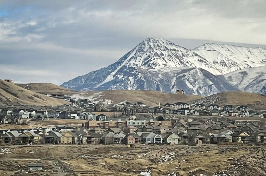
For most of us, we can’t always be in the mountains. Things like work, errands, and familial obligations keep us valley-bound. This is especially true in the Wasatch front of Utah due to very limited housing opportunities in Little and Big Cottonwood.
As a result of all this valley dwelling, the faithful spend many hours staring up at the mountains dreaming of lines and monitoring the snow to see if they're filled in enough. I’m amongst that crowd. As someone who used to commute daily from Salt Lake City to Provo, I’ve analyzed the Wasatch Front on many drives from I-15 - the highway that runs parallel to the mountains. I’m just lucky to have survived those drives despite my constant mountain rubbernecking.
Perhaps due to my constant surveillance, I’ve made an attempt to ski the most eye-catching of lines as seen from I-15, with several left to go. I like to think of them as proud lines. Something you can point to while walking the dog and say, “yeah, I’ve skied that.” Usually, no one is impressed, but I don’t let that deter me. I’m proud.
Obviously, there exists an infinite amount of lines to be skied that are valley visible. It’s kind of like looking into space - the longer you stare, the more stars that become visible.
In no particular order, here are my top four proud lines as seen from I-15 with a touch of beta for your scheming pleasure.
Tolcats Couloir:
Any skier with an affinity for couloir skiing will immediately recognize this one from the valley. It is the very obvious white strip of snow sandwiched between two parallel rocky ridges that create the north and south summits of Mt. Olympus.
Approach - Technically you can start up Neffs Canyon, wrap around the backside, climb Memorial #2 to the saddle and then ski Tolcats. But I think the proper way is to start at Mt. Olympus Trailhead so that later you can reminisce on both the skiing and the heinous ‘shwacking. Follow the summer trail until you cross into Tolcats Canyon and then fight your way up the drainage to the line. Be forewarned, the scrub oak bushwhacking is brutal. Without that deterrent, this line would probably be much more popular.
Skiing Vert: ~1,700’ depending on snow coverage
Slope Angle: low to mid 30s
Ascent Vert: ~4,000’ from Mt. Olympus Trailhead
Lowest Elevation: 4,810’
Highest Elevation: 8,750’
Aspect: West
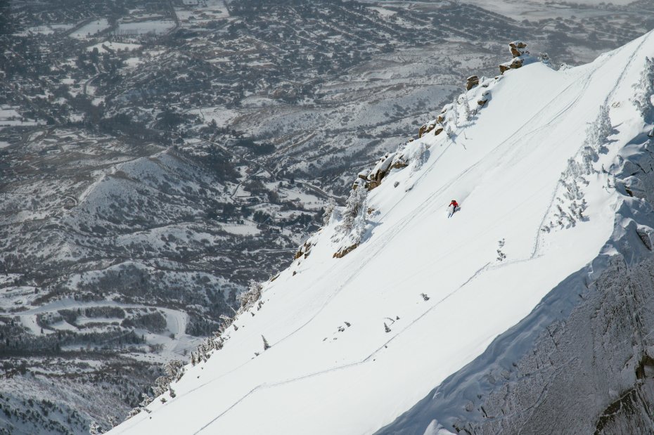
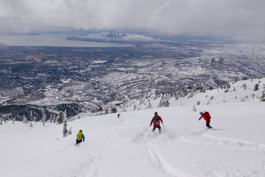
Cold Fusion:
This one can only be glimpsed for a few miles when driving south on I-15 around Point of the Mountain. But that’s more than enough time to be lured in. Starting from the north summit of Mt. Timpanogos, this massive avalanche path begs to be skied. From this highway vantage point, there are two slide paths that diverge from the summit. Cold Fusion is the more direct, looker’s left one.
Approach - Cold Fusion is usually skied in the spring when lower elevation snow has melted and you can park at Mutual Dell Campground up American Fork Canyon to shorten the approach. Some folks ride their bikes up UT-92 as far as the snow allows and then skin westward on the Timpooneke road. For foot traffic, start from the campground in hiking shoes and go up Bear Canyon Trail, where it eventually intersects with Timpooneke. At some point, you’ll most likely switch over to skinning. From the intersection, travel west 2-2.5 miles along the northern end of Mt. Timpanogos Massif. Cold Fusion slide path crosses this road on the left so keep an eye out for it. Once at the base, skin or boot to the top. From the ridge, be sure to admire the views over Utah Valley to the west. If you have time and want to make Cold Fusion feel flat in comparison, walk a little ways south on the ridge and stare down into the insanely steep Grunge Couloir that drops off to the east.
Skiing Vert: 2,820
Slope Angle: 40
Ascent Vert: ~5,000
Lowest Elevation: 6500
Highest Elevation: 11380
Aspect: Northwest
South Face of Lone Peak:
Visible from just about anywhere in Utah County, this big blank face taunts all valley-bound skiers. Almost as if it’s wondering what you’re doing with your life by not carving turns up there. Or maybe that’s just me.
Falling south from the summit of Lone Peak, this face offers several thousand feet of pure blissful skiing. Not too mellow, not too steep. Perfect for big open turns! A pure delight in both powder and corn.
Approach: Start at Schoolhouse Springs Trailhead in Alpine and start skinning up the road. Ideally, the snow line will reach the trailhead but that's not always the case, especially in the spring. It's recommended to bring a pair of hiking shoes in case you need to walk for a ways. Head north along switchbacking roads and trails. After awhile, you will get to meadows labeled as "Hamongogs," (A cursory Google search reveals that this word is an Old Testament biblical reference for meadow.) Keep chugging and the line will come into view. Seeing the line in all of its glory should give you additional motivation to journey on. Continue straight up. Roughly 6,000' vert later, you will get to the ridge. The true summit of Lone Peak requires a few spicy moves but it's not necessary to summit for this line, just drop in wherever looks good!
Skiing Vert: 3-6,000’ Depending on snow coverage
Slope Angle: low to mid 30s
Ascent Vert: 6,000
Lowest Elevation: 5,520
Highest Elevation: 11,230
Aspect: South
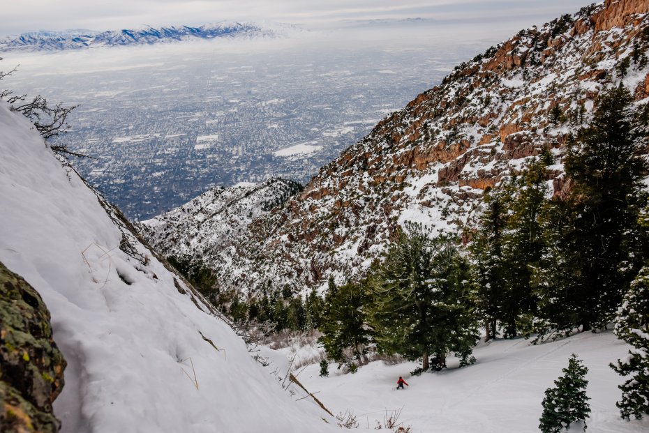
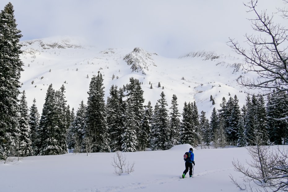
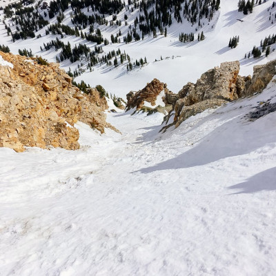
West Couloir of Kessler:
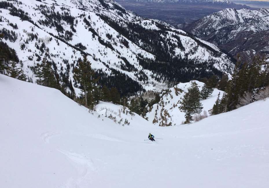
In the midst of a sea of brown and green, a thin straight vertical line can be scoped from the west side of the Salt Lake Valley. From afar, the couloir looks impossibly steep. But once in it, the slope angle is fairly cruiser, for a couloir anyways. Just watch out for the rocky crux partway down. Some years it takes a bit of sideslipping and traversing to successfully skirt around, usually to skier’s right.
Approach: Drive roughly seven miles up Big Cottonwood Canyon and park at the roadside pullout on the southside of the canyon that acts as the Argenta trailhead. Skin the Argenta slide path, up the headwall, and to the ridge. Follow it east to the true summit of Kessler Peak. From there, the West Couloir is, well, the west fall line. Dropping in, it feels like a wide face but it quickly funnels into a distinct line. Ski it and exit back to the road via Mineral Fork. If you didn’t set a shuttle, walk or hitchhike back to Argenta.
Skiing Vert: ~2,700 to Mineral Fork trail
Slope Angle: Mid to upper 30’s
Ascent Vert: 3,400’
Lowest Elevation: 6,700’
Highest Elevation:10,388’
Aspect: West
Up Next: The Dolphin
From northern Salt Lake Valley, find Lone Peak and look to the right. A dolphin will appear and once you see it, you can’t unsee it... 'til you ski it.
Comments
8/26/2021
Reply to this comment:
4/19/2021
“Nobody goes to Coney Island anymore, it's too crowded.” Yogi Berra
This article is about getting people out there on skis! What can you do? Skimo sells stuff. Capitalism is a race to the bottom and possibly bad for the planet. It would be safer to stick with technical advice on gear, but this is how the outdoors is marketed.
Can we at least agree to not use the term, 'Vert:'? And 'stoke'? What about the 'Horiz:'?
(Posted from HQ: Team Wet Blanket)
4/19/2021
Yogi has 11 out of the top 10 best quotes. None contain the word 'stoke'.
It's a bit cynical to call guidebook info 'marketing'. I would be climbing and skiing mountains under socialism, fascism, communism, feudalism, you name it! In fact, we all might be soon, just not sure which one yet.
It's a bit cynical to call guidebook info 'marketing'. I would be climbing and skiing mountains under socialism, fascism, communism, feudalism, you name it! In fact, we all might be soon, just not sure which one yet.
4/20/2021
I'm just waiting for someone to point out that the guide is written by the marketing manager. I guess I have to do everything.
New topic: which 'ism makes the best skis?
New topic: which 'ism makes the best skis?
4/21/2021
Man, and here he thought he was taking a break to write about fun ski lines.
Alpinism makes the best skis.
Alpinism makes the best skis.
4/21/2021
Brilliant
5/15/2021
Alpinism is the cure for everything
8/26/2021
"I would be climbing and skiing mountains under socialism, fascism, communism, feudalism, you name it! In fact, we all might be soon, just not sure which one yet."
My father would often joke of our two family sports:
- "If a dictator banned tennis, I would grumble a lot, but that's about it."
- "However, if a dictator banned skiing, I would join the resistance movement in the mountains ... literally!"
My father would often joke of our two family sports:
- "If a dictator banned tennis, I would grumble a lot, but that's about it."
- "However, if a dictator banned skiing, I would join the resistance movement in the mountains ... literally!"
Reply to this comment:
4/15/2021
At the risk of being a wet blanket, I have to question the merit of articles like this. I only say as much as we have witnessed the fall out from such information here in Alaska. Although the Wasatch does not seem to suffer the access issues we have up here, giving beta to a wide and diversely skilled audience is fraught with peril. Not only does it beg for more crowding, but it can lead to serious consequences that a well-intentioned author may not anticipate. To wit, after newspaper articles were written about two separate destinations in South Central AK, one access point was shut down by private land owners after a church group (50 hikers) came up for a hike and the other may have contributed to the deaths of 3 hikers climbing a line. Both are unfortunate outcomes by an otherwise well-intentioned author.
I think it's best to let skiers find these gems organically rather than shine a bright light on them and how to get there. This avoids being indirectly responsible for any unintentional misfortune.
I think it's best to let skiers find these gems organically rather than shine a bright light on them and how to get there. This avoids being indirectly responsible for any unintentional misfortune.
4/15/2021
With the increasing crowds in the backcountry, I certainly understand this sentiment. However, 1 of these lines is in the Chuting Gallery, 1 is in the 50 Classics, and the 2 others are fairly prominent. They are all skied fairly often and if people want to ski them, it's not hard to find beta. Luckily all 4 have decent access from public trailheads as well. I feel the article is appropriate and in touch with the typical wasatch backcountry user, that is until my favorite zones get shared, haha.
4/17/2021
@Brian Harder These lines get skied every day because they're plainly visible to hundreds of thousands of people. They are all well documented lines. Suggesting that hoarding knowledge and beta as a means of preventing accidents when it's really all about selfishness is pretty transparent and disingenuous. The mountains don't belong to anyone - information should be freely shared among enthusiasts.
5/2/2021
Some mountains belong to someone: https://coloradosun.com/2021/04/30/colorado-fourteeners-14ers-closure-lincoln-democrat-bross/
[note to jbo: you do not need to approve this post if you don't want your very nice website to become a dumping ground. I trust you will delete it if you don't like it. This is a case for guides and education, but I cynically believe it won't cure stupidity and disrespect.]
[note to jbo: you do not need to approve this post if you don't want your very nice website to become a dumping ground. I trust you will delete it if you don't like it. This is a case for guides and education, but I cynically believe it won't cure stupidity and disrespect.]
5/2/2021
Thanks, johnee, love the discussion! Interesting situation with the private and patchwork land for sure. The obvious solution (to every problem) is to have the Federal government print money and (in this case) buy all the dangerous land. We should also forgive student loans for people caught doing something stupid because obviously they were defrauded with their "education".
Wait, is this a political thread? I might be on the wrong forum. I'm going skiing. Down a very obvious line on which I hold (now closed) Alta liable for injury.
Wait, is this a political thread? I might be on the wrong forum. I'm going skiing. Down a very obvious line on which I hold (now closed) Alta liable for injury.
5/2/2021
Who knew? Pretty interesting tangential point around this whole discussion. Indeed, there is a worse endpoint than crowds on your favorite line or peak.
After my comment on the risks of too much beta, I was accused of "hoarding knowledge" and being "disingenuous". In turn, JBo was accused of thinly veiled marketing to improve his bottom line. The truth is, the sport is growing and access and crowding are unavoidable secondary effects. A certain, albeit small, percentage of users are going to be irresponsible and potentially impact the user group as a whole. Social media spray is one of the biggest culprits in driving users to certain areas. Guide books are another.
Ultimately, my point is that stemming some of the avalanche of beta will control and slow the inevitable rise in traffic and the sometimes unforeseen events that come with the onslaught.
5/15/2021
Good grief. The world is ever more flat and interconnected. "Stemming some of the avalanche of beta" to "control and slow the inevitable rise in traffic" is a pipe dream w/r/t any subject matter that is of interest. That's what the internet is actually used for. And let's not leave out "the sometimes unforeseen events that come with the onslaught!!" It's surely "fraught with peril!!"
You are transfixed by a concern for "unforeseen events" and "being indirectly responsible for any unintentional misfortune." This is blatant scare-mongering. It can be much more effectively (helpfully??!) pointed out that beta such as the author has provided will actually HELP ELEVATE safety in the back country.
Have you reviewed all of the pertinent beta on the OP's FATMAP links? Not to mention that these articles are being targeted to a very specific niche of outdoor enthusiasts on the website of a very specialty outdoor retailer in the literal epicenter of one of the most backcountry-rich regions of the United States. Regardless, ANYBODY who ventures into the BC without appropriate beta does so of their own free will, and it is there sole responsibility to likewise be prepared.
You actually cannot wrap every person in bubble wrap before they venture out into the BC, but it's actually very helpful to have these kinds of resources (beta) available for the prudent people who want to be as prepared as possible. INCLUDING - perhaps especially! - if there are pertinent access issues (which in this case there are NOT).
I believe your criticism of the author's well-intentioned, and somewhat playful article, laden with beta as it was (especially with the FATMAP links) is silly.
5/16/2021
Good god. I thought this was dead. First of all, I'm not "transfixed" with any of it but the events are far from unseen. It seems my commentary is not relevant to the area discussed. Fair enough. I don't live there. Without actually pointing this out, my concern was more a general one, perhaps pertinent to less populated areas. While you claim this all to be "silly", it really doesn't feel that way when the reality hits close, whether related to access or fatality. I wrote my comments because both of those issues are fresh in my area and the piece struck a cord. We'll just have to disagree on this one.
8/26/2021
A backcountry ski gear etailer promoting ... backcountry skiing?
Next thing you know, this website will be selling backcountry skiing guidebooks!
Next thing you know, this website will be selling backcountry skiing guidebooks!
3/10/2023
I mean you can literally see all these lines from the freeway… so no use in trying to hide beta
Reply to this comment:
Continued reading
4/27/2021
Skiing the Wasatch in May